Human Orbital Spaceflights
![]()
International Flight No. 212STS-99Endeavour (14)97th Space Shuttle missionUSA |
 |
 |
![]()
Launch, orbit and landing data
walkout photo |
 |
||||||||||||||||||||||||||||
alternative crew photo |
|||||||||||||||||||||||||||||
alternative crew photo |
Crew
| No. | Surname | Given names | Position | Flight No. | Duration | Orbits | |
| 1 | Kregel | Kevin Richard | CDR | 4 | 11d 05h 38m 42s | 181 | |
| 2 | Gorie | Dominic Lee Pudwill | PLT | 2 | 11d 05h 38m 42s | 181 | |
| 3 | Thiele | Gerhard Paul Julius | MS-1, EV-2 | 1 | 11d 05h 38m 42s | 181 | |
| 4 | Kavandi | Janet Lynn | MS-2, EV-1, FE | 2 | 11d 05h 38m 42s | 181 | |
| 5 | Voss | Janice Elaine | MS-3, PLC | 5 | 11d 05h 38m 42s | 181 | |
| 6 | Mohri | Mamoru | MS-4 | 2 | 11d 05h 38m 42s | 181 |
Crew seating arrangement
|
 |
|
||||||||||||||||||||||||||||||||
Hardware
| Orbiter : | OV-105 (14.) |
| SSME (1 / 2 / 3): | 2052-2A (1.) / 2044-2A (3.) / 2047-2A (3.) |
| SRB: | BI-100 / RSRM 71 |
| ET: | ET-92 (LWT-85) |
| OMS Pod: | Left Pod 04 (21.) / Right Pod 01 (28.) |
| FWD RCS Pod: | FRC 5 (14.) |
| RMS: | - |
| EMU: | EMU No. 3014 (PLSS No. 1014) / EMU No. 3016 (PLSS No. 1016) |
Flight
|
Launch from Cape Canaveral (KSC) and
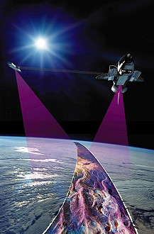
landing on Cape Canaveral (KSC), Runway 33. STS-99 faced a series of launch delays and one scrub before launching successfully. The mission was originally scheduled to fly on September 16, 1999. But in mid-August, the launch date was postponed until October because of wiring concerns throughout the shuttle fleet. With so much of Endeavour's wiring requiring inspection, the target date for launch was shifted to no earlier than November 19, 1999. Shuttle managers later decided to preserve the option to launch either STS-99, or STS-103, the third Hubble Servicing Mission, first. It was decided in October 1999 that STS-103 would fly first, and the launch of STS-99 was set for January 13, 2000. In December that date came under review, and a new launch date of no earlier than January 31, 2000 was set. The scheduled launch on January 31, 2000, was scrubbed because of unacceptable weather conditions. However, late in the count, an anomaly occurred with the No. 2 enhanced master events controller (EMEC), which also would have prevented the launch on that day. The EMEC was removed and replaced and the launch rescheduled until 17:30 UTC on February 11, 2000. About three hours prior to the scheduled launch, an unexpected pressure drop was detected in hydraulic system 1. The pressure drop was determined to be the result of a normal sequence of prelaunch events. Discussions of the pressure drop resulted in a 13-minute, 40-second launch delay. The primary objective of the Shuttle Radar Topography Mission was to acquire a high-resolution topographic map of the Earth's land mass (between 60°N and 56°S) and to test new technologies for deployment of large rigid structures and measurement of their distortions to extremely high precision. The Shuttle Radar Topography Mission (SRTM) was an international project spearheaded by the National Imagery and Mapping Agency and NASA, with participation of the German Aerospace Center DLR. Its objective was to obtain the most complete high-resolution digital topographic database of the Earth. SRTM consisted of a specially modified radar system that flew onboard the space shuttle during its 11-day mission. This radar system gathered around 8 terabytes of data to produce unrivaled 3-D images of the Earth's surface. SRTM used C-band and X-band interferometric synthetic aperture radar (IFSAR) to acquire topographic data of Earth's land mass (between 60°N and 56°S). It produced digital topographic map products which meet Interferometric Terrain Height Data (ITHD)-2 specifications (30 meter x 30 meter spatial sampling with 16 meter absolute vertical height accuracy, 10 meter relative vertical height accuracy and 20 meter absolute horizontal circular accuracy). The result of the Shuttle Radar Topography Mission was close to 1 trillion measurements of the Earth's topography. Besides contributing to the production of better maps, these measurements could lead to improved water drainage modeling, more realistic flight simulators, better locations for cell phone towers, and enhanced navigation safety. The SRTM outboard antenna structure was connected to the end of the mast. It contained a C-band and an X-band antenna, two global positioning system antennas, light emitting diode targets, and a corner-cube reflector. The two outboard antennas could only receive radar signals. Transmitting of radar signals was done only by the main antenna. The C-band and X-band antennas on the outboard antenna structure received radar signals reflected from the ground. The signals were passed down cables to the Shuttle for recording along with the signals from the main antennas. Global Positioning System antennas were used to gather accurate information on the position of the Space Shuttle. Meanwhile, light emitting diode (LED) targets were used by a target tracker on the Attitude and Orbit Determination Avionics (AODA), mounted on the main antenna, to measure the position of the outboard antenna relative to the main antenna. A corner-cube reflector was used by the electronic distance measurement unit on AODA to measure the length of the mast to within three millimeters (1/8 inch). The SRTM mast was made of carbon fiber reinforced plastic (CFRP), stainless steel, alpha titanium, and Invar, the mast was a truss structure that consisted of 87 cube-shaped sections called bays. Unique latches on the diagonal members of the truss allowed the mechanism to deploy bay-by-bay out of the mast canister to a length of 60 meters (200 feet), about the length of five school buses. The canister housed the mast during launch and landing and also deployed and retracted the mast. The mast was deployed and retracted by a motor-driven nut within the mast canister. This nut pulled the mast from its stowed configuration and allowed it to unfold like an accordion. An astronaut inside the Space Shuttle initiated the mast deployment, which took about 20 minutes. The mast also may be deployed manually during an EVA using a hand-held motor if necessary. The mast technology enabled the SRTM system to perform at the high precision necessary to achieve the desired mapping resolution. The mast supported a 360-kilogram (792-pound) antenna structure at its tip and carried 200 kilograms (440 pounds) of stranded copper, coaxial, fiber optic cables, and thruster gas lines along its length. The main antenna was connected to a pallet that in turn was bolted into the payload bay of the Space Shuttle. The system consisted of two antennas and the avionics that computed the position of the antenna. Each antenna was made up of special panels that could transmit and receive radar signals. One antenna was the C-band antenna and could transmit and receive radar wavelengths that are 2.25 inches or 5.6 centimeters long. The second antenna was the X-band antenna. This antenna could transmit and receive radar wavelengths that are 1.2 inches or 3 centimeters long. Both wavelengths were used in the Spaceborne Imaging Radar C-band/X-SAR missions in 1994 for a variety of environmental studies. The L-band antenna, also used during SIR-C/X-SAR, has been removed to save weight. The Shuttle Radar Topography Mission mast was deployed successfully to its full length, and the antenna was turned to its operation position. After a successful checkout of the radar systems, mapping began at 05:31 UTC, less than 12 hours after launch. Crewmembers, split into two shifts (Blue Shift: Dominic Gorie, Janice Voss; Mamoru Mohri; Red Shift: Kevin Kregel, Gerhard Thiele, Janet Kavandi), so they could work around the clock, began mapping an area from 60 degrees north to 56 degrees south. Data was sent to Jet Propulsion Laboratory for analysis and early indications showed the data to be of excellent quality. Mapping proceeded fairly smoothly, but during an attitude-hold period for payload mapping during the second day of flight, it was determined that orbiter propellant usage had doubled from 0.07 to 0.15 % an hour. The increase was caused by a failure of the payload cold-gas thrust system that was used to offset the gravity gradient torque of the mast. As a result of this failure, orbiter propellant was being used at a higher-than-planned rate to maintain the attitude of the vehicle. Measures to reduce the expenditure were evaluated and based on the analysis, enough propellant could be saved to complete the planned 9-day plus science mission. The first of a series of "flycast" maneuvers during the mission was also made on the second day of flight. The flycast maneuver was designed to reduce strain on the almost 200-foot (60 m) mast extending from Endeavour’s cargo bay when adjustments to Endeavour’s orbit were needed. The orbiter, which flies tail-first during mapping operations, is moved to a nose-first attitude with the mast extending upward. A brief reaction control system pulse begins the maneuver. The mast deflects slightly backwards, then rebounds forward. As it reaches vertical, a stronger thrust is applied, arresting the mast's motion and increasing the orbiter's speed. Radar data gathering concluded at 11:54 UTC on the tenth day of flight after a final sweep across Australia. During 222 hours and 23 minutes of mapping, Endeavour's radar images filled 332 high density tapes and covered 99.98 % of the planned mapping area - land between 60 degrees north latitude and 56 degrees south latitude - at least once and 94.6 % of it twice. Only about 80,000 square miles (210,000 km²) in scattered areas remained unimaged, most of them in North America and most already well mapped by other methods. Enough data was gathered to fill the equivalent of 20,000 CDs. Also aboard Endeavour, was a student experiment called EarthKAM, which took 2,715 digital photos during the mission through an overhead flight-deck window. The NASA sponsored program lets middle school students select photo targets and receive the images via the Internet. The pictures are used in classroom projects on Earth science, geography, mathematics and space science. More than 75 middle schools around the world participated in the experiment, which set a record. On four previous flights combined, EarthKAM sent down a total of 2,018 images. Endeavour also saw the recommissioning of the Spacelab Pallet system, used for experiments in vacuum. The 2007 Smithsonian Networks documentary Oasis Earth was made about the mission, containing HD video from inside Endeavour, including many views looking at the Earth below. For example, one highlight is Mamoru Mohri shooting video of the moon and Mount Fuji. |
Photos / Graphics
 |
 |
 |
 |
 |
 |
 |
 |
 |
 |
 |
 |
 |
| © |  |
Last update on March 27, 2020.  |
 |